

Satellite images taken before and after the deadly flash flood near Nepal’s border with Tibet reveal a striking change in the landscape: stretches of green mountainside visible before the disaster are now covered by a broad expanse of brown debris and sediment.The Planet Labs imagery has provided early clues to how the disaster may have started. Experts examining the pictures believe that the lower section of a glacier broke away high in the mountains and plunged hundreds of metres into the valley below, likely carrying or entraining rock and sediment as it fell.Early reports raised an earthquake as a possible trigger, but the US Geological Survey later said the recorded seismic activity came from the collapse itself rather than a separate earthquake, according to news agency Reuters.
Satellite pictures point to the starting point
Sikkim University academic Vikram Gupta, an engineering geology specialist, said the satellite evidence indicated that the collapse began at the glacier’s lower end.“It’s confirmed that a substantial portion of that glacier snout collapsed to initiate the event – probably including or entraining a fair amount of rock and sediment,” Gupta said.Dan Shugar, an earth scientist and associate professor at the University of Calgary, also traced the apparent origin of the disaster to a glacier high above the valley.“What I can see in this morning’s satellite imagery from Planet Labs, the lower part of a glacier broke off at about 5,200 metres and crashed onto the valley floor about 1,200 metres below,” Shugar said.The resulting ice-rock avalanche sent a destructive surge downstream, eventually carrying water, sediment and boulders through the river systems below.A Planet Labs pair taken a day apart captures the border valleys on August 25 and August 26, effectively bracketing the disaster. Other comparisons track the transformation of Manakamana and Khadga Bhanjyang between August 23 and August 26.
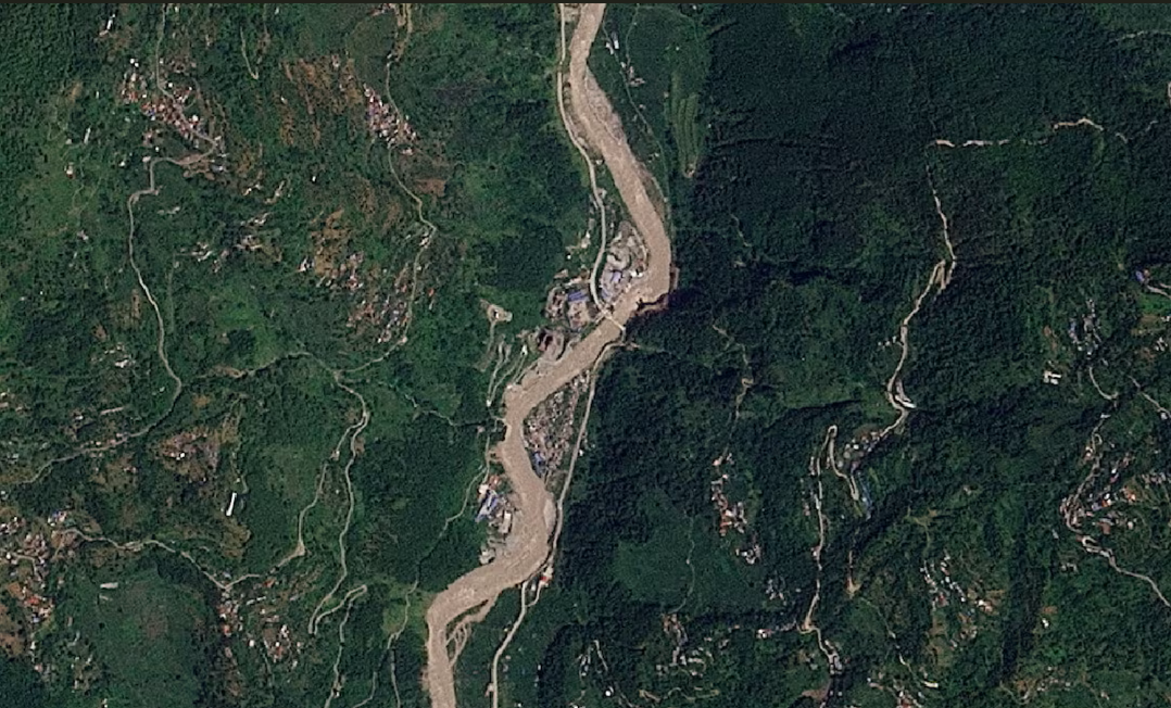
A satellite image shows Manakamana before a flash flood affected the area, Nepal, August 23, 2026. (Photo: Reuters)
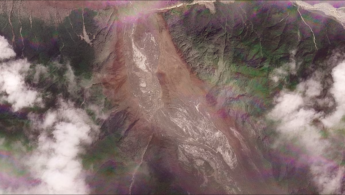
A satellite image shows the valleys near the Nepal-China border on August 26, 2026, after the devastating floods. (Photo: Reuters)
Floodwaters surged through communities along the Bhote Koshi. Rasuwa and nearby districts suffered widespread damage, including to transport links, homes and power infrastructure.
Snow cover changed sharply before disaster
The satellite imagery also showed another significant change in the mountains in the hours before the flood.Comparing satellite images taken roughly a day apart, Shugar noticed a pronounced loss of snow cover.“Some of the glaciers in the valley were covered in snow yesterday and today they are mostly bare ice. So in other words (and I haven’t seen any weather station data yet), it was probably warm,” he said.Whether those warmer conditions contributed directly to the collapse has not yet been established.Nepal’s glaciers have already been undergoing significant long-term changes. A 2023 United Nations assessment found that Nepal’s snow-covered mountains had lost nearly a third of their ice over a little more than three decades because of global warming.It also found that Nepal’s glaciers melted 65% faster over the preceding decade than during the decade before it.
Seismic signal traced to the collapse
An initial assessment by Nepal’s National Disaster Risk Reduction and Management Authority indicated that an ice-and-rock landslide triggered the debris-laden flood in the Lhende River, around 20 kilometres northeast of the Rasuwagadhi border crossing.Prakash Pokharel, a geologist with the authority who reviewed the Planet Labs images, identified the immediate event as an avalanche involving both ice and rock.“The flash floods were caused by an ice-rock avalanche on the Nepali side,” Pokharel said.The USGS assessment provided further clarity on the early earthquake theory. What had initially been identified as a magnitude 4.4 earthquake was subsequently determined to be seismic activity produced by the collapse of glacial rock and ice and the movement of debris, rather than a separate quake preceding the disaster.Shugar said construction activity could also be a factor. On the broader question of global warming, he said “whether climate change played a role is something we will no doubt be looking into in the near future”.
Search for hundreds still missing
Search teams have struggled to reach parts of the disaster zone, where poor weather and communications failures have complicated efforts to locate survivors and assess the damage. Rescue helicopters were also unable to land in Syapru Besi and Timure as conditions and disrupted access hampered operations.Rasuwa, a mountainous district of roughly 50,000 people, is also home to several hydropower projects in areas hit hardest by the disaster.By late Wednesday, police in Nepal had recovered 157 bodies. More than 400 tourists were still unaccounted for in Nepal, with tourism officials saying around 340 were foreigners.Many of those caught in the disaster were travelling through the region on pilgrimages to Kailash Mansarovar.Across the border in Tibet, Chinese state media reported three deaths and 265 people missing in Gyirong, while cautioning that the toll was still being verified. The mudslide also severed road, communications and power connections in the border area.
Surge sent water levels soaring
According to the International Centre for Integrated Mountain Development, floodwaters swept sediment and boulders into both the Bhote Koshi and Trishuli river systems as the surge travelled downstream.At Galchhi, the river reportedly climbed roughly nine metres — about 30 feet — in half an hour.
India evacuates thousands, offers Nepal assistance
Downstream concerns also reached India. Disaster-response units were put on alert in Bihar and Uttar Pradesh as officials watched for the flood surge from Nepal to enter the Gandak river system.An earlier Central Water Commission advisory, issued after a sudden rise in the Trishuli at Furke Khola, about 160 kilometres from India, had raised the possibility of glacial lake outburst flood activity near the Nepal-China border.
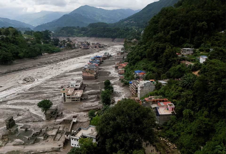
A drove view of mud covered properties following a flash flood at Trishuli in Nuwakot district, Nepal, August 26, 2026. (Photo: Reuters)
Districts along the Gandak’s downstream course in Bihar and Uttar Pradesh were told to maintain heightened surveillance.About 5,000 residents had already been moved to safety from six Bihar districts by Thursday, with preparations covering as many as 10,000 to 12,000 people if further evacuations were required.Prime Minister Narendra Modi conveyed condolences to Nepal Prime Minister Balendra Shah and offered humanitarian assistance, saying Indian teams were working with Nepalese authorities on rescue and relief.The disaster also comes against a backdrop of more frequent and increasingly powerful extreme events across the Hindu Kush Himalayas, including floods, landslides, avalanches and droughts.For now, the satellite record is helping investigators reconstruct how the catastrophe unfolded — from the apparent collapse of ice and rock high in the mountains to the destructive torrent that swept through valleys, settlements and river systems far downstream.

