


Humberto becomes a hurricane in the Atlantic. Maps show its forecast path.

Humberto grew into a hurricane early Friday morning, and the storm was expected to strengthen significantly over the weekend, but there were no immediate watches or warnings issued for the U.S. by the National Hurricane Center.
The storm is one of two systems swirling over the western Atlantic that could potentially bring some downstream impacts to parts of the Southeast U.S. coast, from Florida up to North Carolina, the director of the Miami-based hurricane center, Michael Brennan, said.
There were no coastal watches or warnings in effect due to either storm as of Friday morning.
Hurricane Humberto forecast and path
As of early Friday morning, Humberto was located about 465 miles northeast of the northern Leeward Islands. It was moving northwest at about 3 mph with maximum sustained winds of 75 mph.
“Significant strengthening is forecast, and Humberto is expected to become a major hurricane this weekend,” the hurricane center said Friday morning.
CBS News 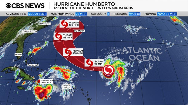
Tropical-storm-force winds extend outward up to 105 miles from the center of Humberto.
It is the eighth named storm of the 2025 Atlantic hurricane season. The tropical storm comes on the heels of Hurricane Gabrielle, which is not impacting land and is forecast to head farther out into the Atlantic.
Another storm system brews over the Caribbean
The hurricane center is also closely monitoring a second storm system over the northeast Caribbean in the Atlantic, near Humberto.
CBS News 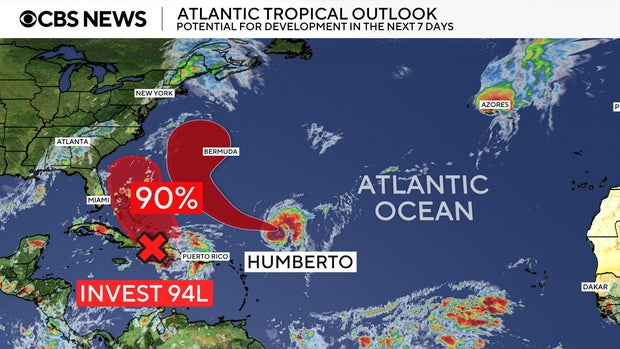
The system is likely to become a tropical depression late this week, forecasters said.
It is likely to bring heavy rains near Puerto Rico and the Dominican Republic through Wednesday before strengthening near the Bahamas, according to the NHC.
CBS News 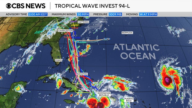
There is also a possibility it could interact with Humberto — a phenomenon known as the Fujiwhara effect, in which two different storms converge and either join or spin around each other. But CBS News meteorologist Nikki Nolan said such an outcome is not considered likely in this case.
[title_words_as_hashtags

